

Open User Map
Stop relying on Google Maps and let your visitors add, edit, and organize locations on your WordPress map with zero coding.
About Open User Map
Open User Map is a revolutionary WordPress plugin that transforms how you integrate interactive, community-driven maps into your website. Designed for the modern web, this tool eliminates the traditional barriers of complex coding, expensive Google Maps API keys, and tedious setup processes. At its core, Open User Map allows your website visitors to become active contributors by adding and editing locations directly on your map. This creates a dynamic, living map that grows and evolves with your community's input. The plugin is built for a wide range of users, from local business owners and tourism boards to real estate agents, event organizers, and educational institutions. Its main value proposition is simplicity married with power. You get a robust approval workflow to moderate all user submissions, ensuring quality and accuracy, alongside extensive customization options like custom fields, marker categories, and unique map styles. The latest trend of user-generated content is fully leveraged here, turning a static map into a collaborative tool that boosts engagement and provides fresh, real-time data. With a stellar 5-star rating and over 15,000 active installs, it is the second most popular map plugin on WordPress.org, proving its reliability and effectiveness in the current market. It is a no-code solution that puts the power of mapping directly into the hands of your visitors, making it a must-have for any site looking to offer a modern, interactive, and community-focused experience.
Features of Open User Map
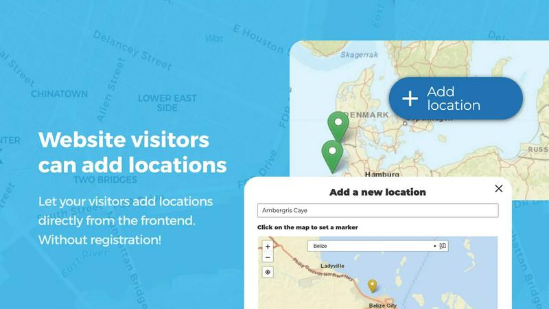
Frontend User Submissions and Editing
Empower your website visitors to add and edit locations directly from the frontend of your site, without ever needing to access the WordPress admin dashboard. By clicking an 'Add location' button, users can place a marker on the map, fill in details like name, description, and custom fields, and submit it for your review. The editing capability is equally powerful, allowing users to return and update their existing locations. This ensures your map is always current and accurate, driven by the very people who use it. This feature is a game-changer for community projects, directories, and any site that thrives on user participation, creating a self-sustaining ecosystem of location data.
Marker Categories and Advanced Filtering
Organize your map's data with a sophisticated system of marker categories, each customizable with unique icons and colors. This goes beyond simple organization; it creates a visual hierarchy that makes your map instantly understandable. Visitors can then use an advanced filter interface to quickly narrow down locations based on these categories. A single location can even belong to multiple categories, ensuring it appears in all relevant filters. This feature is essential for complex maps with diverse data, such as a city guide with restaurants, parks, and museums, allowing users to find exactly what they need in seconds.
Lines, Areas, and Custom Image Maps
Break free from the limits of simple point markers with the ability to draw lines, routes, paths, and polygons directly onto your map. This feature is perfect for highlighting hiking trails, marking service areas, defining event zones, or outlining construction boundaries. Distances and area sizes are calculated automatically, providing valuable measurements for your users. Even more groundbreaking is the Custom Image as Map feature. Upload any image, such as a floor plan, event layout, or product diagram, and transform it into a fully interactive map. Users can place markers on this image with the same powerful functionality, opening up endless possibilities for unique, branded mapping experiences.
Upvotes, Star Ratings, and Opening Hours
Integrate community-driven quality control and essential business information directly into your map. The Upvotes & Likes feature allows visitors to highlight the best locations or flag inappropriate content, making your map self-curating. The Star Rating system takes this a step further by enabling a full 1-5 star rating scale, automatically promoting top-rated spots. For business directories, the Opening Hours custom field is a standout, displaying beautifully styled business hours with a live "Open Now" indicator that updates based on the current time. These features transform your map from a simple directory into a dynamic, social, and highly useful tool for your audience.
Use Cases of Open User Map
Community-Driven Local Business Directory
Create a hyper-local directory where residents and visitors can add their favorite cafes, shops, and services. The frontend submission feature allows anyone to contribute, while the approval workflow ensures only legitimate businesses are listed. Use marker categories to separate restaurants from retail, and enable star ratings so the community can highlight the best spots. The opening hours feature makes it a practical tool for people looking for places that are open now, turning your site into the go-to resource for local discovery.
Interactive Event and Festival Mapping
For large events like music festivals, conferences, or farmers' markets, use Open User Map to create an interactive site map. Upload a custom image of the venue layout and allow attendees to place markers on stages, food vendors, restrooms, and information booths. The Lines & Areas feature can highlight pathways and restricted zones. Advanced filtering lets attendees search for specific types of vendors or activities. This creates an invaluable tool for attendees to navigate the event and discover everything it has to offer.
Real Estate and Property Showcasing
Real estate agents can build a dynamic map of available properties that potential buyers can filter by price, type, or features using custom fields. Allow sellers or agents to submit new listings directly from the frontend. The Lines & Areas feature is perfect for outlining school districts, neighborhood boundaries, or walking distances to amenities. This creates a powerful, user-friendly property search tool that keeps your listings current and gives buyers a comprehensive view of the market.
Educational Campus and Facility Guides
Schools, universities, and large corporate campuses can use Open User Map as an interactive guide. Upload a custom image of the campus map and allow departments, student groups, or facilities management to add markers for buildings, parking lots, dining halls, and key offices. Use categories to differentiate between academic buildings, dorms, and sports facilities. This creates a living guide that can be updated as the campus changes, providing an essential resource for new students, visitors, and staff.
Frequently Asked Questions
Do I need a Google Maps API key?
No, you do not need a Google Maps API key. Open User Map is designed to work without one, using its own mapping system. This eliminates a major cost and technical hurdle, making it incredibly easy to set up and use. You can have a fully functional, interactive map running on your site in minutes without any external API dependencies.
Can I control what users submit?
Yes, absolutely. Open User Map includes a powerful approval workflow. When a visitor submits a new location or edits an existing one, it goes into a moderation queue. You can then review the submission from your WordPress dashboard and approve, reject, or edit it before it goes live. This ensures that all content on your map is accurate, appropriate, and meets your standards.
Is this plugin compatible with my WordPress theme?
Yes, Open User Map is designed to be highly compatible with most modern WordPress themes. It uses standard WordPress coding practices and includes a shortcode system, so you can place the map on any page or post. The plugin's frontend interface is also responsive and will adapt to your theme's layout, ensuring a seamless integration.
Can I customize the look and feel of the map?
Yes, you have extensive customization options. You can change marker colors and icons, set custom map styles, and add your own branding. The plugin also supports custom fields, allowing you to tailor the information collected and displayed for each location. For ultimate control, you can even upload a custom image to use as your map, perfect for floor plans or unique layouts.
Pricing of Open User Map
Open User Map offers a free version available on WordPress.org that includes core features like frontend submissions and basic mapping. For advanced functionality, the PRO version is available. You can start a 7-day free trial of the PRO version with no credit card required. The trial does not automatically convert into a paid subscription. To get specific pricing for the PRO version, including license tiers for single sites or multiple sites, you should visit the official Open User Map website.
Similar to Open User Map

Built2WinWeb AI SEO
AI‑ready websites, WebAgentScan SaaS, and Indexing Pack. MCP, A2A, llms.txt — hand‑coded PHP, complete ownership, flat‑fee, free quote.

Webleadr
Webleadr instantly finds and contacts local businesses without websites, unlocking a flood of hot web design leads for you.

Idearium
Idearium crafts high-impact websites that drive growth with cutting-edge design and SEO.

FilexHost
Effortlessly host and share your files with instant URLs using FilexHost's simple drag-and-drop interface.

Crawlkit
CrawlKit is an API-first platform that simplifies web scraping, delivering structured data from any site with a single.

Best Boilerplates
Find and compare top trending SaaS boilerplates to launch your AI app fast.

Shadcn UI Kit
Accelerate your web development with the Shadcn UI Kit's ready-to-use dashboards, templates, and components at 40% off.

Clio Websites
Clio Websites creates AI-driven, high-converting websites that elevate your brand and boost customer engagement.